GIS and remote sensing techniques have become essential and powerful tools for tackling civil engineering problems. Remote sensing data frequently correlates spatial data with their properties, making it beneficial in this discipline. Remote sensing can be used to extract several themes such as geology, terrain, drainage, and hydrology. Integrating the following topics aids in the speedier resolution of civil engineering challenges. Sanitation, urban growth, new road alignment, and irrigation project design are all areas where remote sensing technology is commonly used. GIS and remote sensing data are commonly used to construct models that integrate socioeconomic, demographic, and natural resource information.
Read More
What is AI:
It is the art and science of creating intelligent machines, particularly intelligent computer programmes. It resembles the task of using computers to understand human intelligence. Basically, Artificial Intelligence refers to the intelligence displayed by machines. Artificial Intelligence (AI) has grown extremely prevalent in today’s world. It is the simulation of human intelligence in computers that have been programmed to learn and mimic human actions. These machines can learn from their mistakes and do activities that are similar to those performed by humans.
AI in Civil Engineering:
Deep learning technologies have been effectively employed in a variety of industries for many years, including civil engineering. Indeed, with the emergence of complex constructions such as skyscrapers, machine learning techniques grabbed centre stage in the sector a long time ago. We are seeing the application and growth of AI in the construction industry more than ever before, with intelligent algorithms, big data, and deep learning machines transforming productivity performance.
A passive solar building is one that is designed and constructed by taking use of the factors found in the surrounding environment, particularly the sun’s movement. If planned and built according to a few passive solar building criteria, passive solar structures will be warm in the cold winters and cool in the hot summers. The sun’s thermal energy is used to both warm and cool the structure in a passive solar design, which is built and placed to shelter the sun during the hotter summer months.
A well-designed passive solar home reduces heating and cooling loads first through energy-efficiency technologies, then uses solar energy to partially or entirely meet those reduced demands. Because modern homes have low heating loads, it’s critical to avoid oversizing south-facing glass and ensuring that it’s adequately shaded in the spring and fall to minimise overheating and increasing cooling loads.
Read More
3D printed concrete is an emerging technology that has many advantages like reduced labour cost, less emission of carbon dioxide in the atmosphere, reduced cost, less time consuming, ease of use, ability to change properties as per desire and many more. A case study on building houses using 3D printed concrete and conventional concrete brought into light that cost is effectively reduced using 3D printed concrete which is beneficial for people having low income or for refugees who have nowhere to go and construct houses affordably. Many types of 3D printing can be observed out of which the perfect method is selected based on various criteria. Some admixtures can also be added for better strength and workability that will facilitate ease of extrusion through the nozzle. Compaction or vibration is seen absent here as the process is completely automatic. However, some labours may be needed to move the 3D printed elements from one place to another. Other properties like bond strength, compressive strength and flexural strength are also taken into account for monitoring the effects of standoff distance as well as printing speed on tensile bond strength. Apart from this, some future projects are also expected that can produce homes on other planet and can open an array of opportunities.
Introduction
The role of drones in construction is new and something which can bring revolution to the construction world. Earlier all the work had to be executed manually starting from drawing to building houses or detecting structural defects that arise from time to time. All these have been replaced by technology to a large extent. Calculations like building estimates needed extensive time in calculating with the help of a pen, paper, and calculator but now software is available that reduces time and effort for doing cumbersome calculations. Similarly, drones provide various advantages that are beneficial for saving time and labor work. Not only this, accuracy in work increases, and better perception of the ongoing work is facilitated. All the pros and cons along with additional data are discussed here.
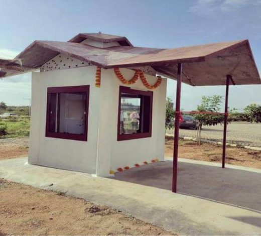
Recently, the first bio-brick-based building in India was inaugurated at IIT Hyderabad on 2nd September 2021. It is a part of the project BUILD (Bold Unique Idea Lead Development) to demonstrate the strength and versatility of the material. It is a sample building that is made of bio-bricks and supported by a metal framework. It is a perfect example of “wealth from waste”. The roof of the sample building is made of bio-bricks over PVC sheets. It helps to reduce heat. The inside and outside walls of the house are cement plastered to protect the bio-bricks from rain.

Fig 1: India’s first bio-brick based building, IIT Hyderabad
Introduction:
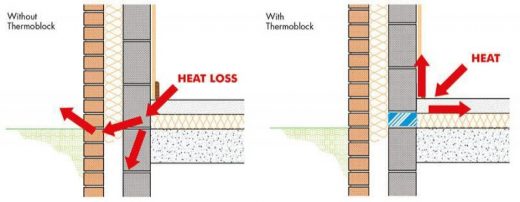
The movement of heat across an object that is more conductive than the materials it is surrounded by is referred to as thermal bridging. Heat flows through a path of least resistance created by the conductive material. Thermal bridging can be a significant cause of energy loss in homes and buildings, resulting in increased utility bills. The object’s overall thermal resistance is reduced as a result of thermal bridges. Thermal bridges result in heat transfer into or out of conditioned space and are commonly discussed in the context of a building’s thermal envelope.

Fig 1: Concept of Thermal Bridge
Source: Civil Engineering Quora
Practically no building is perfectly fire-proof. Because every building contains some materials which can catch fire easily. The perspective of the architect or engineer should be to plan, design, and construct the building such that it ensures the safety of occupants from the outbreak of fire due to any reason. The fire resistance of a building is expressed in terms of hours when it is subjected to fire of known intensity. Fire protection word is used to cover the following aspects:
- To prevent fire and reduce the number of outbreaks of fire.
- To reduce the fire both externally and internally.
- Use of fire extinguishing apparatus.
Nowadays, sustainability has become a primary concern in our daily lives due to its hazardous environmental impact. Therefore, people worldwide have started opting for sustainable homes as it leads to low energy consumption, low cost in maintenance of homes, saving natural resources for future generations, etc. This small step can be a giant leap for humanity towards sustainable living.
A sustainable home is an efficient, resource-friendly, energy-efficient, and water-efficient home that will last with quality systems. Low-impact, high-performance materials are used in sustainable homes that contribute significantly to the environment. Some points are essential that matters the most, i.e., size, location, orientation, outlook, transportation, infrastructure, recyclable materials, and many more.
Introduction
Any pipe or tube designed to transport treated drinking water to consumers is referred to as a water pipe. Large diameter main pipes that supply entire towns, smaller branch lines that deliver a street or group of buildings, and small diameter pipes located within individual buildings are all examples. When plumbing was first introduced into homes in the United States in the early twentieth century, materials such as cast iron, terra-cotta, copper, and galvanized steel were used. Lead piping was also popular and was the preferred material for plumbing pipes until World War II. However, as the public’s understanding of lead poisoning grew, the use of lead piping declined, particularly for potable water. After WWII, galvanized screw piping became the preferred material for plumbing pipes inside the home, and copper gained popularity a few decades later, in the 1970s. Polybutylene was introduced later in the 1970s. It was later discovered that this material is harmed by chlorine exposure, so it is now prohibited in many building codes. Earlier, clay pipes were utilized by the Greeks to bring water to their dwellings and public structures.
